

How to Walk in CoMo: Crossing US-63 at Clark Lane
How to Walk in CoMo: Crossing US-63 at Clark Lane
In which I walk to the least walkable part of the city

A note: One of the challenges of writing about walking in America is its dual nature of being pleasant and enjoyable and of being unpleasent and sometimes dangerous. Many people who write about walking end up focusing a lot of their time and words on the second part. I am trying hard not to be one of those people. I’d like to encourage more people to walk and you don’t do that by telling them it’s a dangerous, awful, unpleasent activity.
I don’t believe walking is a dangerous, awful, unpleasent activity. I believe it is a safe, lovely, and pleasant activity that everyone should do more of partially because it is so safe, lovely, and pleasant. Still, there is no way to write about walking in American honestly without recognizing that there are many places where walking can be dangerous.
As part of trying to understand this, I am going to be doing several posts broadly about pedestrian fatalities in my home city of Columbia, Missouri. This is the first. This one will focus on how to get to one of the parts of town that is the most dangerous for pedestrians.
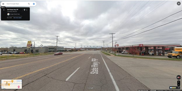
Clark Lane has all the food options: Taco Bell, Pizza Hut, Burger King, McDonalds, White Castle, China Garden. A couple of gas stations: Quik Trip, Cenex and a handful of motels (ranging from the SpringHill Suites by Marriott at $169 a night to the Super 8 at $54) plus a Home Depot to tie the place together. It is the kind of place you might stop for the night if you were doing a long drive along I-70. A tent Under US-63 visible on Streetview and an abandoned shopping cart indicate that it is also a place for those whose transience is somewhat more persistent.
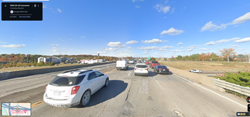
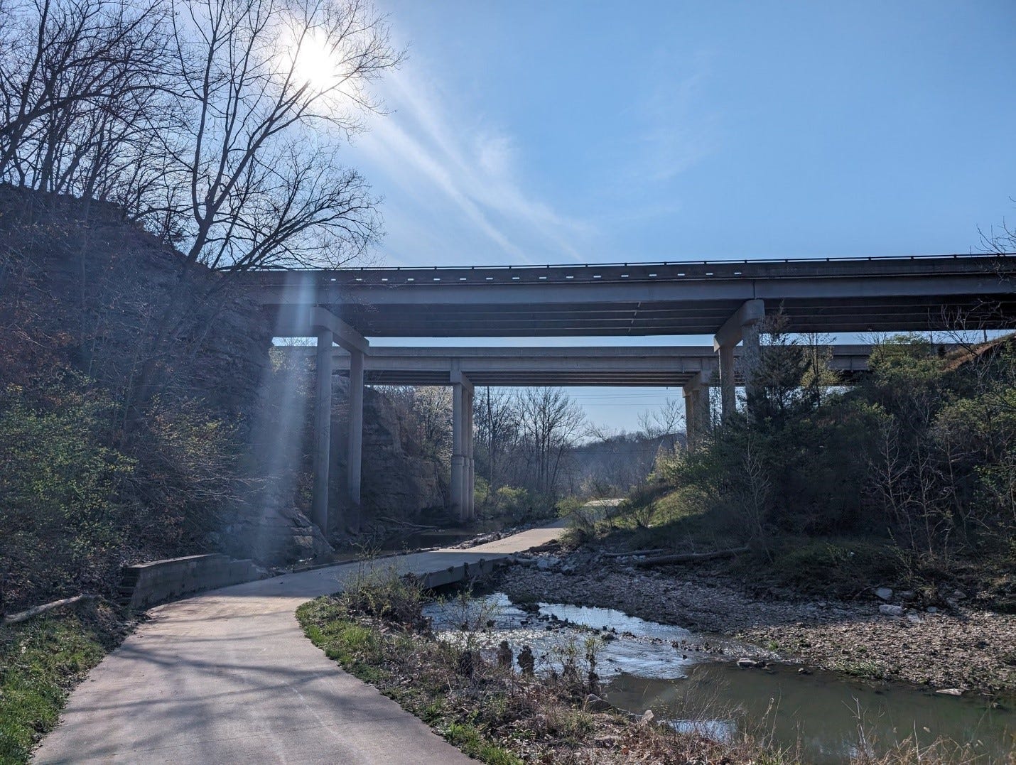
From the ground it looks like this:
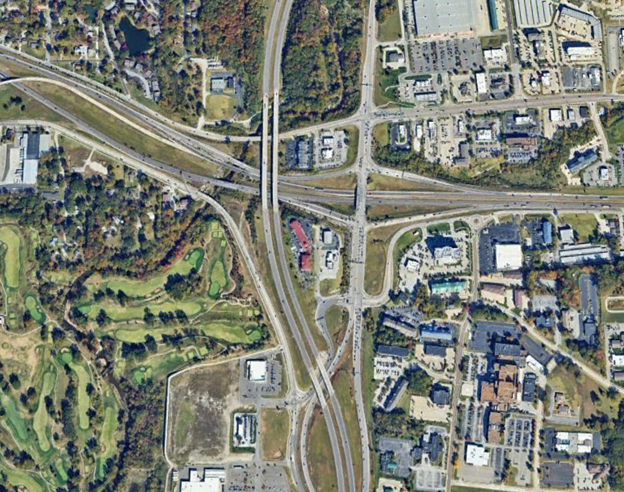
From the air it looks like this.
Despite having walked through much of Columbia. I had, prior to this week, never walked here. I’ve always felt stymied by this part of town. It is a mess of highways, on-ramps, very busy roads with fast-moving traffic, and it frankly never seemed worth it. There are much easier places to walk to if you want to get Taco Bell.
Then I created a map of pedestrian fatalities in Columbia, and this part of town really stuck out1. The map below shows pedestrian fatalities in Columbia for the past 10 years, the cluster of five, where the two highways meet is the area I’m talking about. This area is the worst part of the city for walking, the kind of place that often gets called “unwalkable”. So, to get a sense of the place, and to fulfill my own sense of completionism, I decided to walk there.

First though I had to to get there. Highways are major blocks to walking in a city, uncrossable in the same way rivers are uncrossable. Here, where two major highways come together is probably the most challenging place for walking in Columbia. Coming from the south side of I-70 and the West Side of 63, I would have to cross both I-70 and US-63.
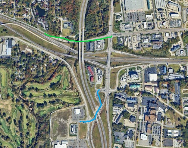
I decided to work through my options virtually: From the satellite view there are really two potential ways to do it: one is to take Clark Lane eastbound under 63. (green) The other is using Conely Road (blue).
The Conley road (blue) option looks like this:

No sidewalk. No shoulder. There does maybe appear to be a trodden dirt desire path of sorts on the left side of the road. But following that keeps you on the wrong side of Conely road. The best option is to cross Conley Road midblock, just south of the Ramada where its only two lanes.
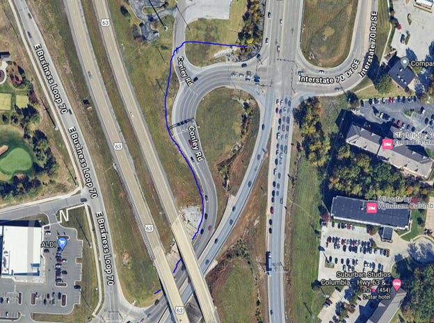
Then you still must figure out how to cross the I-70 Connector, which is 4 lanes in each direction, and while there is an intersection, it has no pedestrian signals. Should you manage that, you still have to get across I-70. The only way to do this is to try the I-70 connector bridge, which has 6 lanes, essentially no shoulder, and absolutely no place to bail out to. I quickly realized this was not an option I was comfortable with trying.
That left Clark Lane (green line) as the only viable option.
This is already a bit of a cheat as it requires crossing I-70, somewhere else, most likely at Paris Road, a better part of a mile west of this spot, but there isn’t another choice, so this is what I did. This section of Clark Lane itself is just fine for walking along, there is a sidewalk, and while it wouldn’t make my top 10 favorite streets, as it has a lot of interstate noise, its fine, the gentle downhill even provides a little bit of view.

Then you arrive at the US-63 Underpass, and the sidewalk just sort of stops.
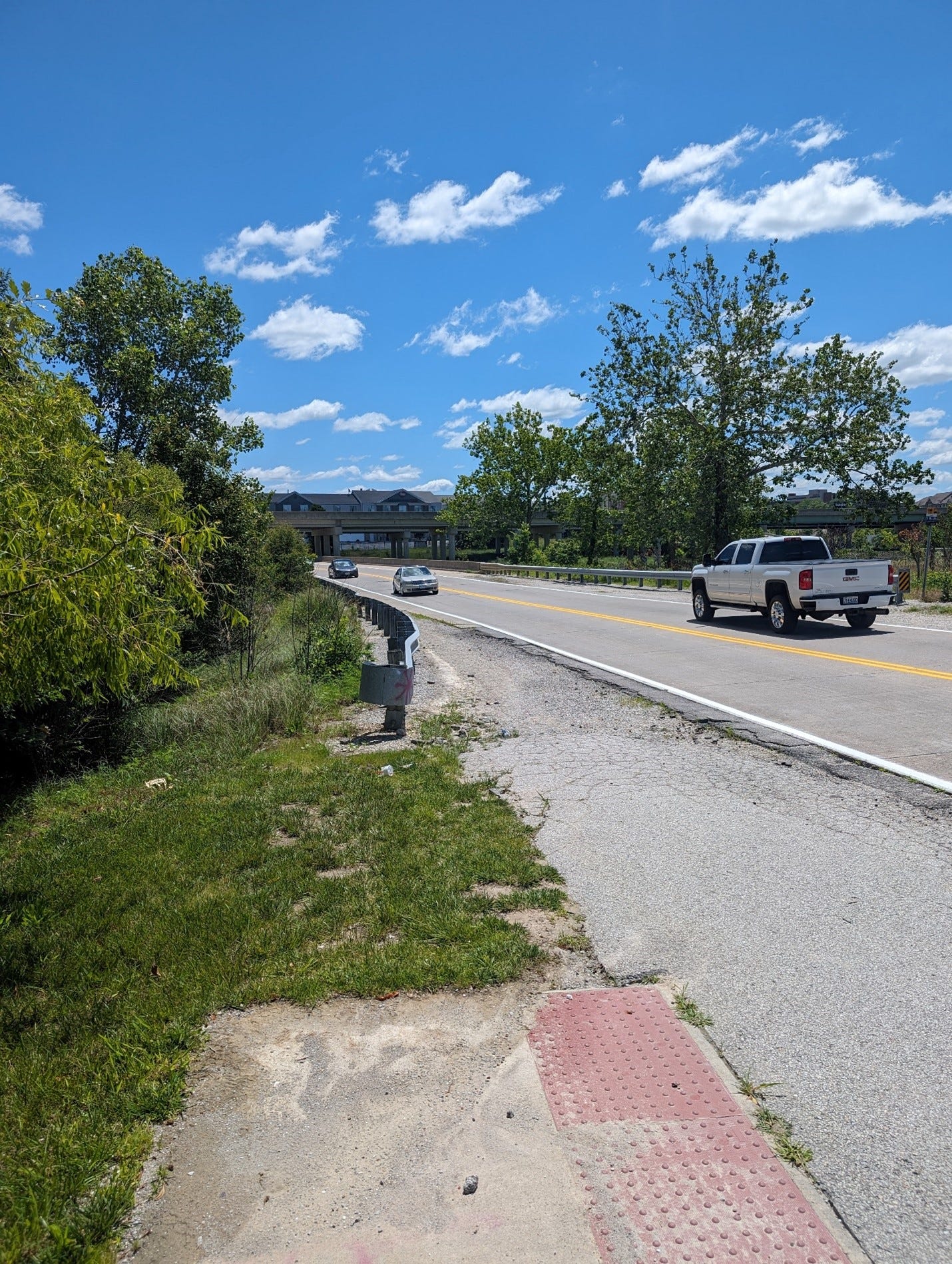
Beyond this isn’t completely unwalkable, there is a significant shoulder, you can see oncoming traffic ok, and the traffic isn’t that fast, but its pretty bad. The big problem is this is also where the road crosses Hinkson creek, so much of it is a bridge.

This bad stretch is roughly a third of a mile (about a 4 min walk) of this before you arrive at an absolutly tragic looking, but still very welcome, pedestrian crossing.
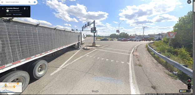
This is the route I took. Honestly it wasn’t as a bad as I thought it would be, but it isn’t going to be added any of my regular set-walks2, and is listed with two cautions on my Columbia MO walking map. One caution is on the bridge, and one right before you arrive at the pedestrian crossing, with the yield sign, curve, and guardrail on the wrong side making the situation dubious.
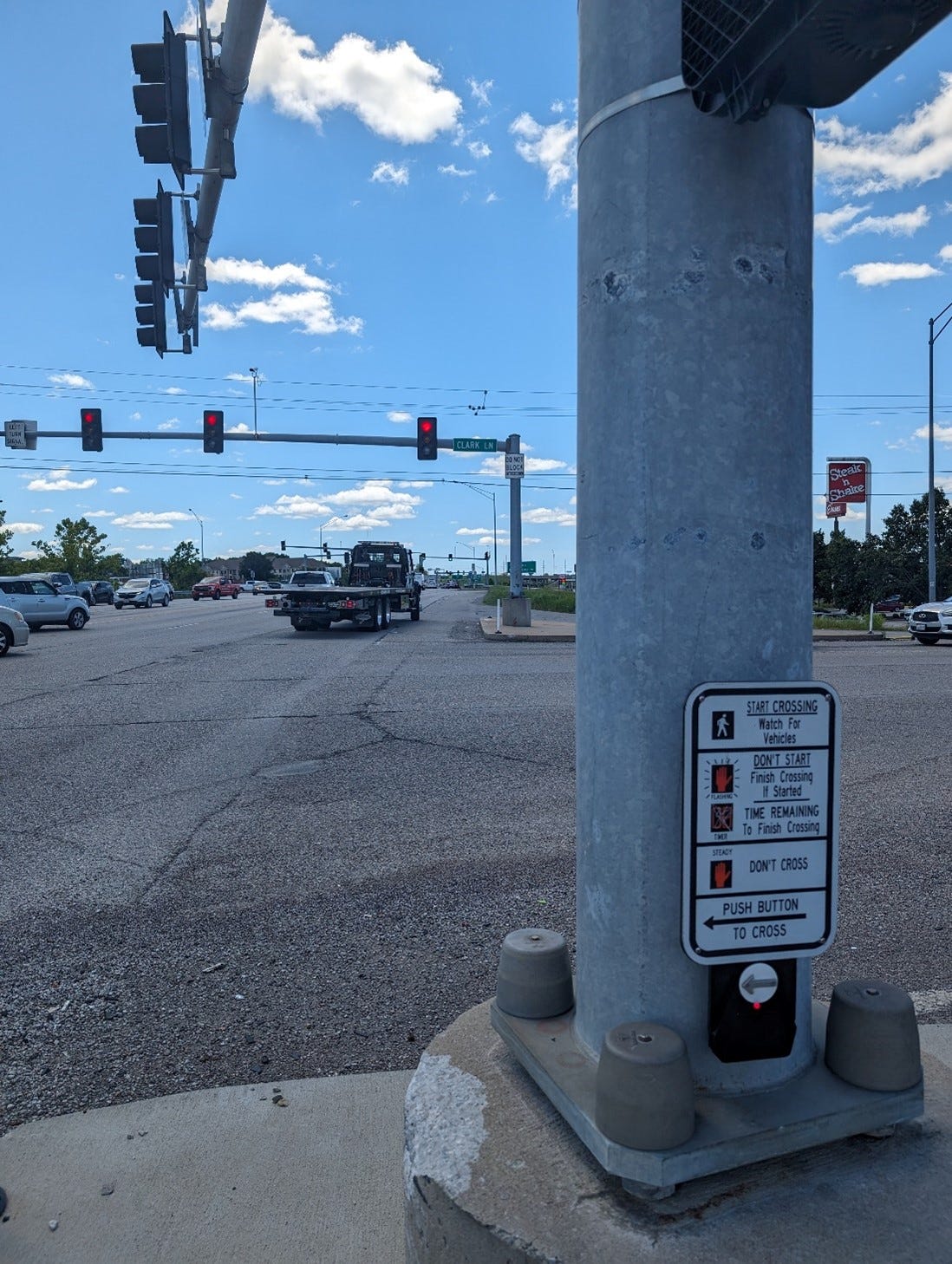
There is no crosswalk to cross Clark Lane North/South at this intersection. This really isn’t acceptable, and I think has probably contributed to both of the Clark Lane pedestrian fatalities (more on that in another post). I had originally planned on cross at this intersection, but after not liking my chances decided to simply stick to the north side of the street. I continued up Clark Lane, keeping my head on a swivel for turning cars, and eventually made my way to the Hominy Creek trail for a more relaxing return. (After getting Taco Bell, naturally).
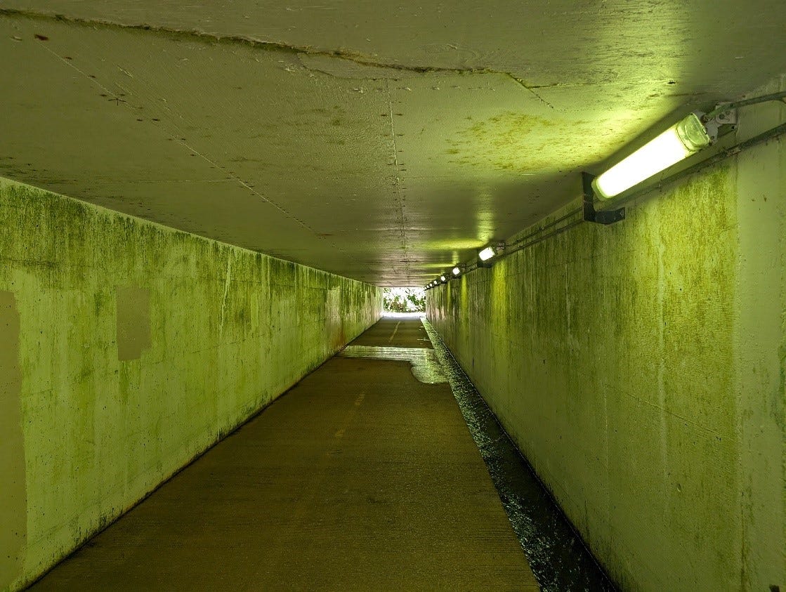
There are better options for crossing US-63, but none of them leave you anywhere close to this area. The best option (and how I returned home) is to take the Hominy Creek Trail which goes under US-63 at a rather fetching spot, and under I-70 at a less fetching, less still when lightly flooded, tunnel.
Of course, this only works if you don’t really care about where you are. Cross I-70 at the Hinkson Creek underpass and you are 1.3 miles (~25 min walk) from the QuickTrip at Clark Lane and US-63. Other crossings of US-63 include another good trail option using the Grindstone Creek Trail further south, a decent sidewalk option, but extremely far south at Discovery Parkway, a slightly dubious sharrow/shoulder along Stadium, and a quick dash across a bridge well north at Mexico Gravel Road. None of these leave you anywhere close to this part of town.
The Clark lane/63 underpass is another example of the waking network almost connecting, but not quite. I mentioned this before in my post about how it ought to be easier to walk to the MKT. Rock Quarry Road just south of Stadium is another point, where campus/University Hospital could be much better connected to the network of trails in Grindstone Nature Area or the Hinkson Creek Trail, but instead you have an awful stretch of South Rock Quarry Road to contend with. As far as the Clark Lane section, a sidewalk along all of Clark Lane is the obvious improvement to make, but there are other options. A dirt path plus a footbridge over Hinkson Creek would be just fine, allowing walkers to bypass the scary bridge entirely, and would not require messing with the highway. Little improvements in targeted areas really would make a big difference to how easy the city is to navigate on foot.
Based on a similar map from this recent report by Smart Growth America: https://smartgrowthamerica.org/dangerous-by-design/
“Set Walk” is a term Geoff Nicholson uses in The Lost Art of Walking that describes a walk taken regularly.
Rather glad you survived. Now you can cross the Mouse Trap on foot, but there will be no Taco Bell reward.